Quick access
Discover Antarctica
Antarctica is a continent that is covered with ice, located in the extreme south of our planet. Surrounded by the Southern Ocean, it is the coldest, driest, and highest region in the world.
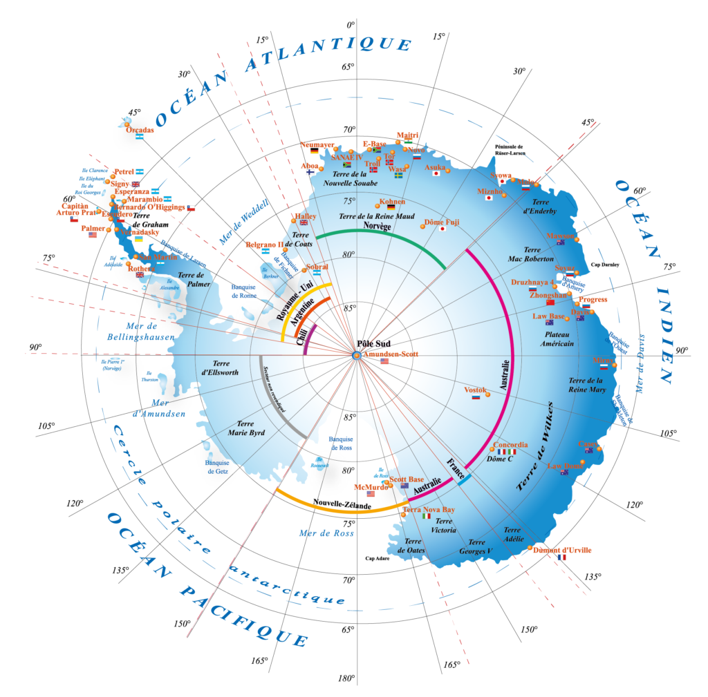
Since 1959 and the signing of the Antarctic Treaty, this continent has been dedicated to peace and science. France maintains two stations there:
Stations
The Dumont d’Urville station
Dumont d’Urville is the historic French station. Located on the coast of Adélie Land, it can accommodate up to 120 people in summer since 1955 and is maintained by approximately twenty overwintering personnel in winter.
 En savoir plus
Concordia station
Concordia is a French-Italian station located at the very heart of Antarctica. Since 2005, it has welcomed 12 to 15 overwintering personnel and up to 70 people during the austral summer.
En savoir plus
History of Antarctica
In ancient times, long before Antarctica was even discovered, it was assumed that the Earth was a symmetrical sphere and therefore it was also assumed that a continent existed in the Southern Hemisphere to counterbalance the landmasses found in the Northern Hemisphere. Aristotle himself talked about the need for this balance and for the existence of a Terra Australis.
Navigators in the 16th century, e.g. the Portuguese navigator Bartolomeu Dias, Magellan and then Francis Drake, gave proof that this Terra Australis was not part of Africa or America.
In 1773, James Cook was the first navigator to cross the Antarctic Circle (66°33’39”S). He was stopped by ice in January 1774 at the record latitude of 71°10’S. He was also the first explorer to sail completely round the continent (but without knowing it).
The continent was seen for the very first time by the Russian Bellinghausen, in January 1820.
The American seal hunter John Davis was the first person to land on the continent in February 1821.
In 1838, French navigators led by Dumont d’Urville set out in search of the magnetic South Pole. On 21 January 1840, they landed on the continent at a place that Dumont d’Urville named Adélie Land, in honour of his wife.
In 1897-98, the Belgica led by Adrien de Gerlache, carried out the first overwintering on the ice sheet of the Antarctic Peninsula. Then, in 1899, the Norwegian Borchgrevink installed the first base on the continent, at Cap Adare (east of Adélie Land), where he was the first to spend the winter (overwinter) on land.
The geographical South Pole was reached on 14 December 1911 by the Norwegian Roald Amundsen, one month before the British explorer Robert Falcon Scott and his team arrived there (16 January 1912). The return journey cost the lives of Scott and his four unfortunate companions.
In 1950, the Expéditions Polaires Françaises (EPF), founded by Paul-Emile Victor, built the Port-Martin base in Adélie Land. The buildings were destroyed by a fire in January 1952 and the French team settled on Petrel Island in the Geology Point Islands 5 km off the mainland, on the current site of the Dumont d’Urville station built in January 1956.
During the International Geophysical Year of 1957, a large number of expeditions were run and 12 countries set up 48 operational stations, mostly on the coasts but also some on the ice sheet (Russian Vostok base, American Amundsen-Scott base).
The Charcot base was built in 1957, 320 km from Dumont d’Urville and was permanently closed in December 1959.
The Antarctic Treaty was signed on 1 December 1959 and came into force on 23 June 1961. It froze all territorial claims over the continent.
Geography of Antarctica
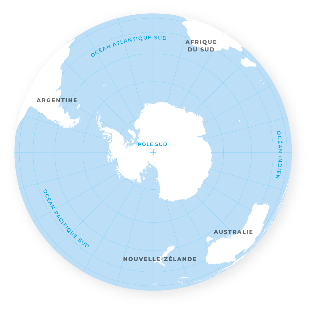
Antarctica is a continent that is located at the South Pole and which is surrounded by the Southern Ocean. Its northern limit is found at the 60th parallel south. It is comprised of a large island, also called Antarctica, and a series of small islands in the Southern Ocean.
Antarctica covers a surface area of more than 14,000,000 km2, which doubles in size with the pack ice that forms in winter up to 800 km from the shoreline.
Antarctica is divided in two by the Transantarctic Mountains located near the Antarctic Peninsula between Ross Sea and Weddell Sea.
The part facing the Atlantic and Indian Oceans is called East Antarctica. It forms a plateau extending approximately 10 million km2 covered with ice and reaches 4,030 metres, roughly in the centre of the plateau.
West Antarctica includes the Antarctic Peninsula, which stretches towards Chile, where most of the land that is not covered with ice is found on the continent and which is surrounded by numerous islands.
Approximately 98% of Antarctica is covered by the Antarctic Ice Sheet with an average thickness of 1.6 km.
The Vinson Massif, the highest point in Antarctica with an altitude of 4,892 metres, is located in the Ellsworth Mountains.
Although the relatively easy-to-reach Antarctic coast is fairly well known, many areas of the plateau are still unknown.
Geology of Antarctica
The Antarctic was born at least 3.8 billion years ago (Ga), as indicated by the age of the oldest rocks found there. It then continued to grow larger the through build-up and breakup processes of the various supercontinents: Nuna (a.k.a. Columbia and Hudsonland) (1.8 to 1.6 Ga BP), Rodinia (1.3 to 0.93 Ga), Pannotia (0.68 to 0.55 Ga), and then Gondwana (0.45 to 0.25 Ga).
The breaking-up of Gondwana resulted in Antarctica progressively becoming a separate entity (a rift first separated Africa from India, then India completely broke off followed by a block comprising New Zealand, Australia and Antarctica, Australia separated from Antarctica then the opening-up of the Drake Passage isolated Antarctica from South America), which began to drift towards the South Pole around 60 million years (Ma).
Thirty Ma BP ago, Antarctica had become separate and the opening-up of the Drake passage, south of Cape Horn, created a circumpolar current which isolated the continent climatically by blocking the passage of temperate influences from the other oceans: Atlantic, Indian and Pacific Oceans
Around 14 Ma BP, the Antarctic became an ice sheet: i.e. a continent covered by a thick ice cap. However, ice is flowing at depth and towards the ocean, and it is believed that these ice flows that are present today are younger than 900,000 years old.
There are two major geological domains in the Antarctic:
The oldest domain is in the east and is made up of continental remnants that form rock cores called ‘cratons’ surrounded by belts formed during telescoping (overlapping) events caused by continental drift. Erosion has planed down all of the upper parts of these configurations and now only the deepest folded zones remain today: these are the ‘roots’ of ancient mountain ranges.
The western part has been reworked several times (by fusion then magmatism); therefore, it is the youngest domain. Today, two mountain chains give structure to the morphology:
- the Antarctic Cordillera, which is dotted with volcanoes and earthquakes, with a similar origin to that observed in the Andes Cordillera.
- the Transantarctic chain caused by a rift (tearing of the lithosphere), which cuts through the continent over 3,000 km and is dotted with volcanoes. The best known of these is Mount Erebus, which is still active today and continually propels chlorine into the air; the effects of this on the ozone layer is not well known.
The Ice Cap and pack ice
Over 98% of Antarctica is covered by ice. Through the use of radar and satellites, combined with field observations, it is possible to determine the topography of the ice sheet and the thickness of the ice as well as to monitor any changes.
The average thickness of the ice sheet is 1,300 m in West Antarctica and 2,200 m in East Antarctica. Its maximum thickness is almost 5,000 m. Thus, its base is more than 2,500 m below sea level. It is fed by snowfall which is more significant on the coastal regions. Rainfall in the interior of the continent is less than half of that received by the hottest deserts. Year after year, snow accumulates and transforms into compact ice. Under the effect of this extra weight and gravity, the ice flows from the centre of the cap towards the continent’s coasts. These movements are quite slow in the centre of the ice sheet (e.g. several tens of centimetres per year) and then gradually become faster (e.g. several hundred metres per year) on the large glaciers which, at the coast, drain the continental ice out towards the ocean.
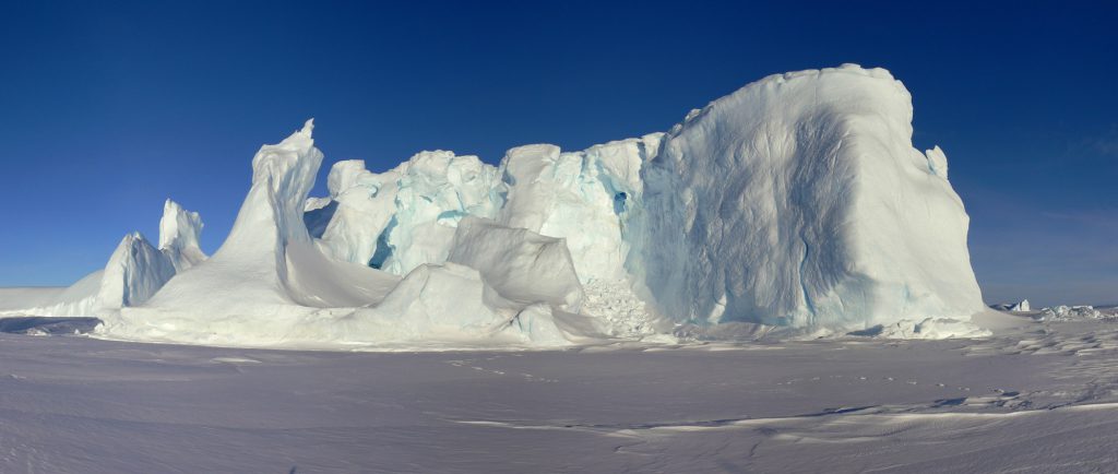
In some sectors, the ice sheet is extended by immense ice floes called ice shelves, which spread out and float on the Southern Ocean; the combined surface area is larger than 1.5 million km². The three largest ones are the Amery, Ronne and Ross ice shelves, with a surface area almost as large as France.
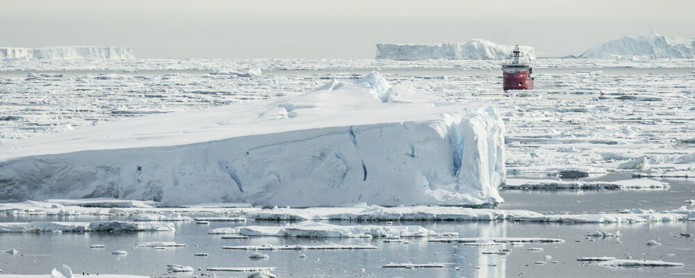
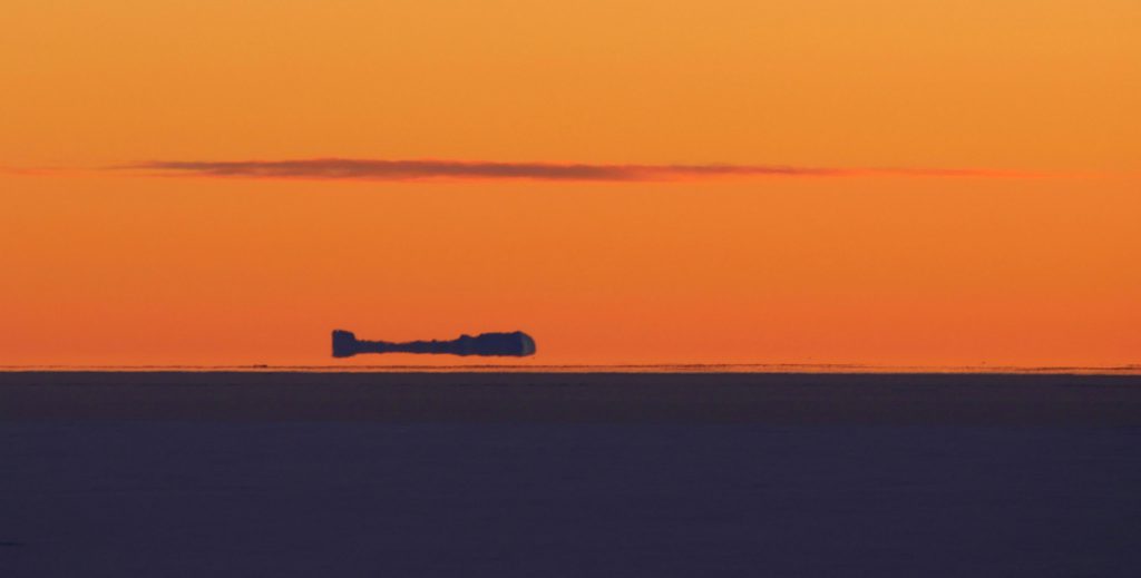
As they advance onto the ocean, ice-shelves break up into blocks that may be more than 400 m thick and which may form tabular icebergs. Some may even be larger than the size of Corsica.
Every winter, the ocean around Antarctica freezes. Seawater, due to its salinity, begins to freeze on the surface starting from -1.8°C. As it is quite fragile when first being formed, this ice is destroyed every time there is a storm. Then, as the cold intensifies, the sea ice thickens and expands to form pack ice, which has an average thickness of 40-60 cm. At its maximum, in September, the surface area of the pack ice can reach 20 million km2, which doubles the size of the frozen surface area of the Southern Hemisphere.
Within the existing pack ice, there are persistent and recurrent areas of open water called polynyas which are linked to the upwelling of deep water. The largest one is located in the eastern Weddell Sea, which reaches 250,000 km² in size.
In February, towards the end of the austral summer, the pack ice has completely broken up and most of the coasts are freely accessible. Therefore, it is only possible to access the continent during two to three months in summer, however this is not even certain as the ice conditions depend heavily on the erratic weather conditions.
The annual rhythm of sea ice formation and melting, especially given the enormous amount of this ice, has a profound influence on the global ocean circulation, heat exchanges between the ocean and the atmosphere, and the biology of the oceans in the Southern Hemisphere.
Climate
Because of the altitude, the low sunshine, the isolation by the Antarctic Circumpolar Current and the reflective power of the ice (80% of the light rays are reflected towards the atmosphere), Antarctica is the coldest place on the planet.
The lowest temperature measured by remote sensing by NASA was estimated at -93.2°C at Dome Argus in 2010, and the record temperature measured on site is -89.2°C measured at Vostok in 1983.
The climate is very contrasted between the coast where maximum temperatures are between 5 and 15°C and the interior of the continent where minimum temperatures fluctuate between -80 and -90°C. This is due to the altitude and the influence of weather fronts that rarely penetrate the interior of the continent, which remains very cold, very dry and not very windy, while the side is subject to both these fronts from the ocean and katabatic winds that can blow from the interior of the continent at more than 200km/h.
The average wind speed is relatively moderate in the central regions (10 to 20 km/h) and higher on the coasts (30 to 70 km/h) where gusts can reach record speeds such as the 320 km/h recorded at the Dumont d’Urville base.
Paradoxically, there is very little snow in Antarctica. Atmospheric depressions have difficulty penetrating the interior and most of the precipitation occurs on the coast. The interior of the continent is a veritable desert: over an area of 5 million km², less than 5 cm of water equivalent falls each year, and often less than 2 cm! It therefore took a considerable amount of time to build up the several kilometers thick layer of ice that makes up the ice sheet.
Political status
 Internationally, Antarctica has been a continent dedicated to peace and science since 1959. Following the success of the International Geophysical Year of 1958, the nations carrying out activities in Antarctica wanted to ensure that it would continue to be possible to explore this part of the world for scientific purposes without the risk of being subject to international geopolitical or commercial mercantile discord.
On 1 December 1959, South Africa, Argentina, Australia, Belgium, Chile, the United States, France, Japan, Norway, New Zealand, the United Kingdom and Russia signed the Antarctic Treaty in Washington DC which governs the relationships between the signatory countries with regards to the territories located to the south of the Antarctic Polar Circle.
Today this Treaty unites 54 nations: the original 12 Consultative Parties, plus 17 other nations, and 25 Non-Consultative Parties.
The Treaty only allows peaceful activities to be carried out in Antarctica. The continent is dedicated to science, and therefore each signatory country is free to set up a research station wherever it wants. It freezes territorial claims: the seven States that have claimed part of the continent are not required to renounce them but cannot report them, and it is forbidden to make any new claims.
Since 1958, numerous conventions, committees and councils have been created in order to add to the commitments entered into by signing the Treaty and to specify the conditions of access and human presence in Antarctica.
Adélie Land, a region of East Antarctica where the Dumont d’Urville station is set up, has been claimed by France, which has entrusted its management to the French Southern and Antarctic Territories (TAAF), a French overseas territory which also brings together the Crozet and Kerguelen Archipelago districts, the Saint-Paul and Amsterdam Islands and scattered islands in the Indian Ocean. Therefore, persons found in Adélie Land are placed under the authority of the prefect of TAAF, represented on site by a district manager.
Fauna and flora
The centre of the Antarctic continent is particularly hostile to all forms of life, and therefore Antarctica’s fauna and flora are concentrated on the coasts and in the Southern Ocean.
Given that its waters are very rich in nutrients and oxygen, the Southern Ocean is home to a large amount of biomass. Therefore, plankton and krill are the main source of food in the food chain as they are both very abundant in polar waters. Krill is made up of several crustacean species that feed on plankton; the most common species, Euphausia superba, resembles a shrimp. The mass of the krill, which undoubtedly represents the most abundant biomass on Earth, may exceed 500 million tonnes! In summer, krill can form schools extending over an area covering 500 km²; their pink colour can be detected by fishermen as well as by satellites! The staple of the food chain, krill are the main diet of fish, whales, seals, penguins and other birds.
The Southern Ocean is also home to 300 species of fish, out of the 20,000 species found across the world. The most emblematic species are undoubtedly the icefish, Champsocephalus gunnari, whose blood does not contain haemoglobin and Notothenia which secretes antifreeze proteins.
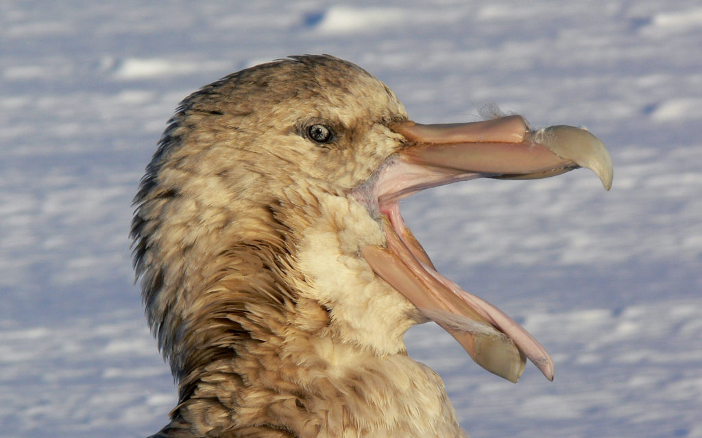
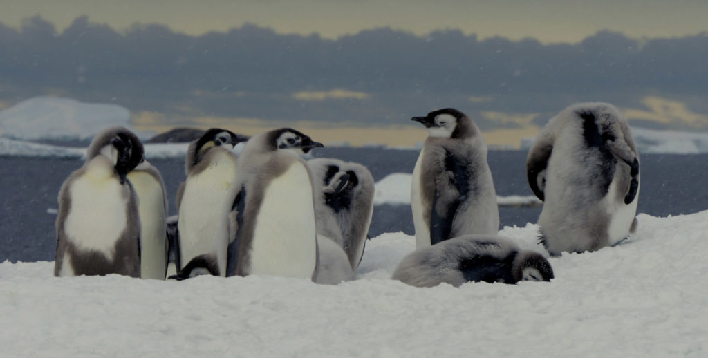
About 40 species of birds, representing 200 million individuals, live in the Austral zone; half of them breed during the summer on the rare land and islands that border the continent. The most common species are petrels, skuas, terns and of course penguins.
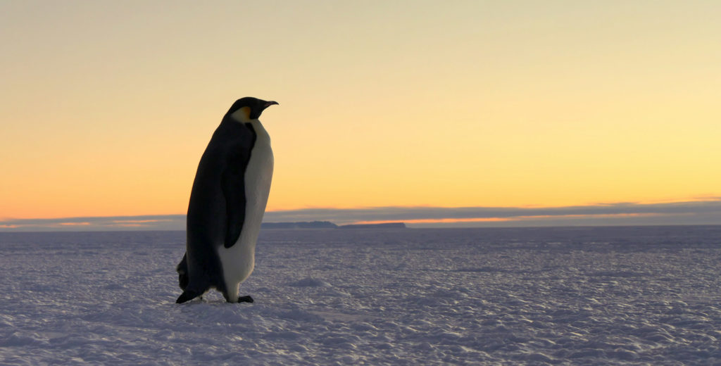
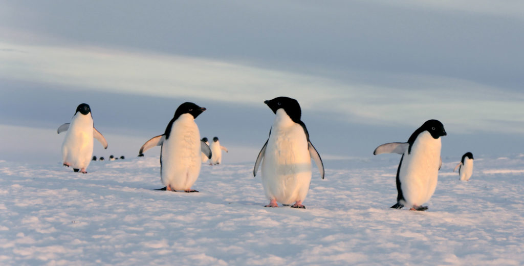
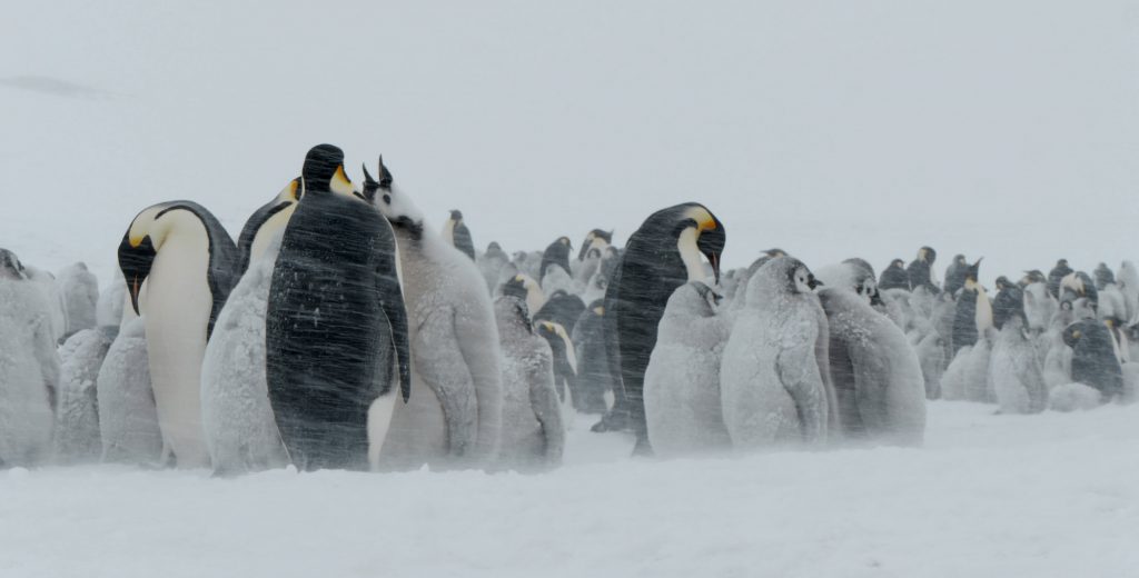
Penguins are birds that cannot fly but extremely well adapted to the marine environment and to the cold. Four species live in Antarctica: although chinstrap and gentoo penguins visit the peninsula, only Adélie and emperor penguins nest on the shorelines. Penguins congregate by the thousands on the pack ice or on the
coasts, forming what are called rookeries in order to keep warm. The emperor penguin is the largest and heaviest of the penguins. It is only found in ten or so colonies, each made up of thousands of individuals.
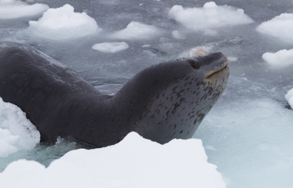
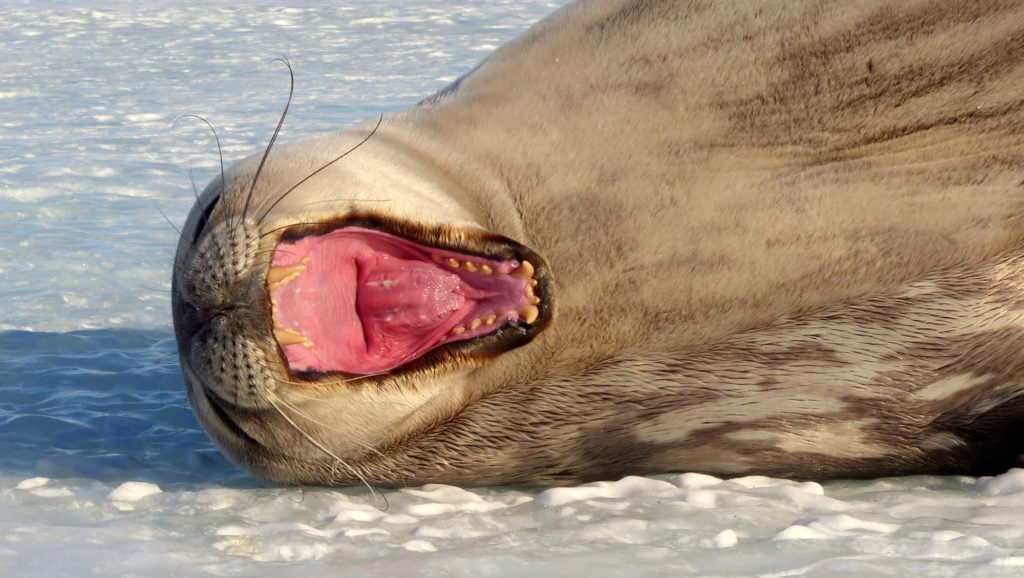
The Mammals, all of which are marine, are represented by eight species of cetaceans (whales, killer whales, etc.) and pinnipeds (seals and sea lions), four of which breed near the continent. However, sea lions are not found off the peninsula and there are no walruses. Several species are only found on Antarctica: crab-eater seals are the most common species, with than 15 million individuals, Weddell seals are the largest species (3 m long and weighing over 400 kg); the rarer leopard seal primarily eats penguins: they can swallow up to 20 a day!
On the surface of Antarctica, the flora is very poorly developed: lichens and moss are found on rocks, microscopic algae are found in ice or in often frozen lakes, and two flowering plants are found on the more temperate Antarctic Peninsula. Therefore, most the flora on Antarctica is attached to the seabed where they evolve in the water column.